STORM WATCH: Rain, snow, wintry mix diminish for most of Hudson Valley
Storm Watch Team Meteorologist Matt Hammer says it will be wet and windy for most of the region today, and some spots in northern Hudson Valley will get snow.
•
Dec 16, 2022, 11:53 AM
•
Updated 631 days ago
Share:
More Stories
2:09

Saturn to be visible this weekend, with best viewing on Sunday
23h ago1:39

Why has hurricane season quieted down?
2ds ago
LIVE BLOG: News 12 weather updates
10ds ago1:04

Cooler temperature trend into start of meteorological fall
10ds ago1:34

Greenwood Lake leaders warn visitors to use common sense in the heat
10ds ago2:26

Heat & humidity strengthen, storm chances weaken, to bring a pleasant end to week
11ds ago2:09
Saturn to be visible this weekend, with best viewing on Sunday
23h ago1:39
Why has hurricane season quieted down?
2ds agoLIVE BLOG: News 12 weather updates
10ds ago1:04
Cooler temperature trend into start of meteorological fall
10ds ago1:34
Greenwood Lake leaders warn visitors to use common sense in the heat
10ds ago2:26
Heat & humidity strengthen, storm chances weaken, to bring a pleasant end to week
11ds agoNews 12 Storm Watch Team Meteorologist Mike Favetta says the rain, snow and wintry mix will decrease across the Hudson Valley before a sunny and dry weekend.
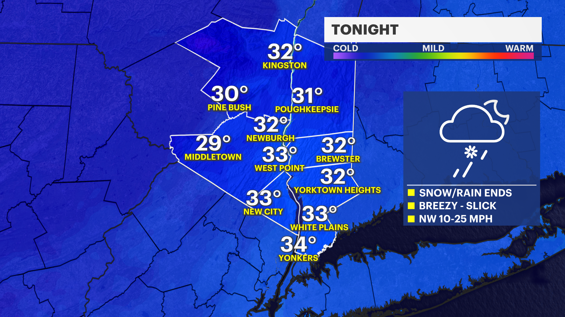
NOW: Rain tapers off in Westchester County only. Flurries remain through the evening in Orange, Dutchess and Ulster counties. Little to no additional accumulation is expected. Skies clear out by 10 p.m.
NEXT: A winter weather advisory continues for Orange County and Eastern Ulster and Eastern Dutchess Counties until Saturday 7 a.m. A winter storm warning continues for Western Ulster County until 10 a.m.
FORECAST:
Periods of rain showers continue with a wintry mix and snow at times still mainly in Northern Orange and up into Ulster Counties. Travel is much more slippery in these areas. Highs in the 30s to mid 40s.
TONIGHT: Periods of rain and snow showers, tapering off around 6 p.m. to 10 p.m. for the most part. Slick spots remain with lows around the upper 20s to low 30s. Staying breezy.
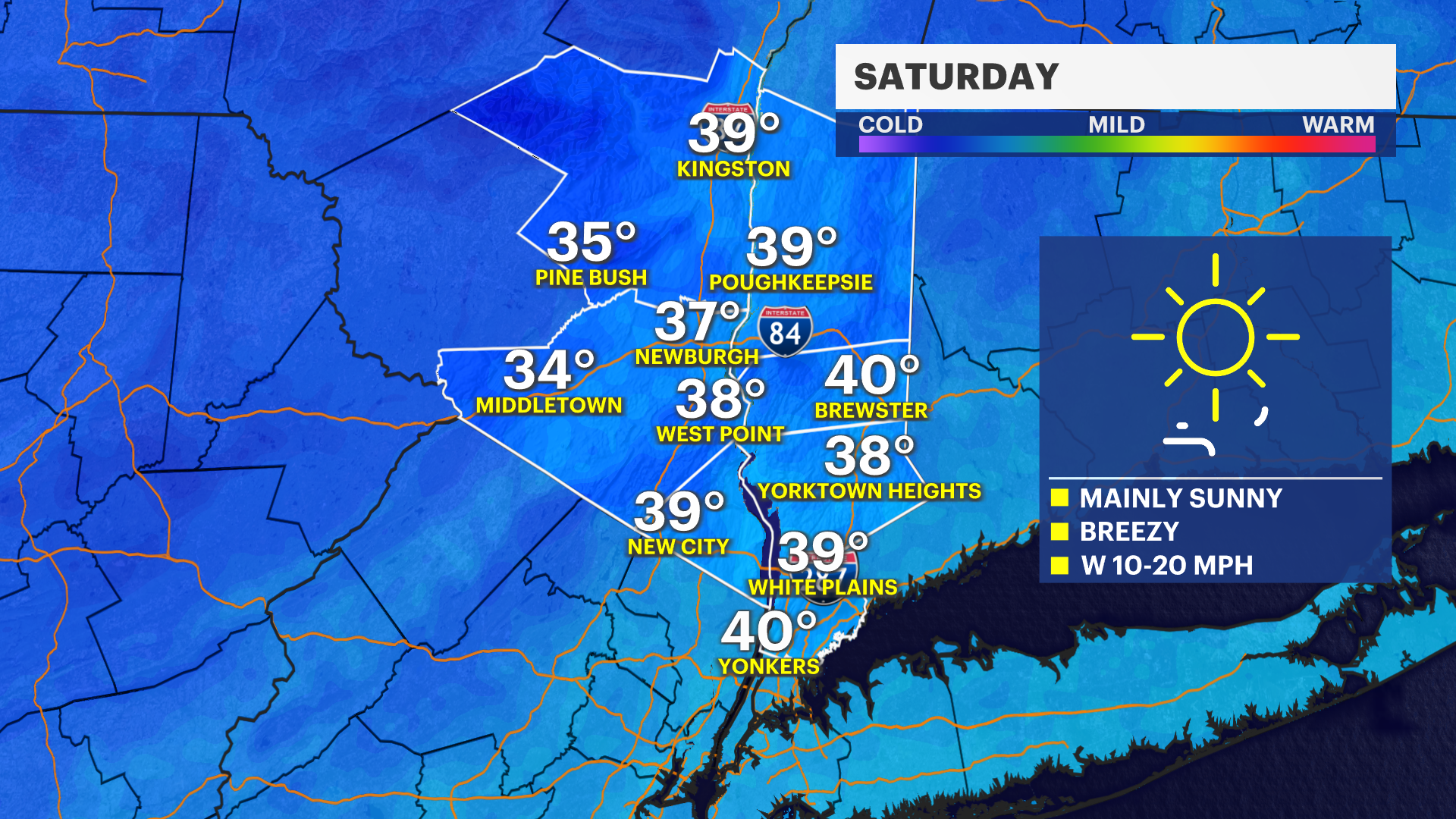
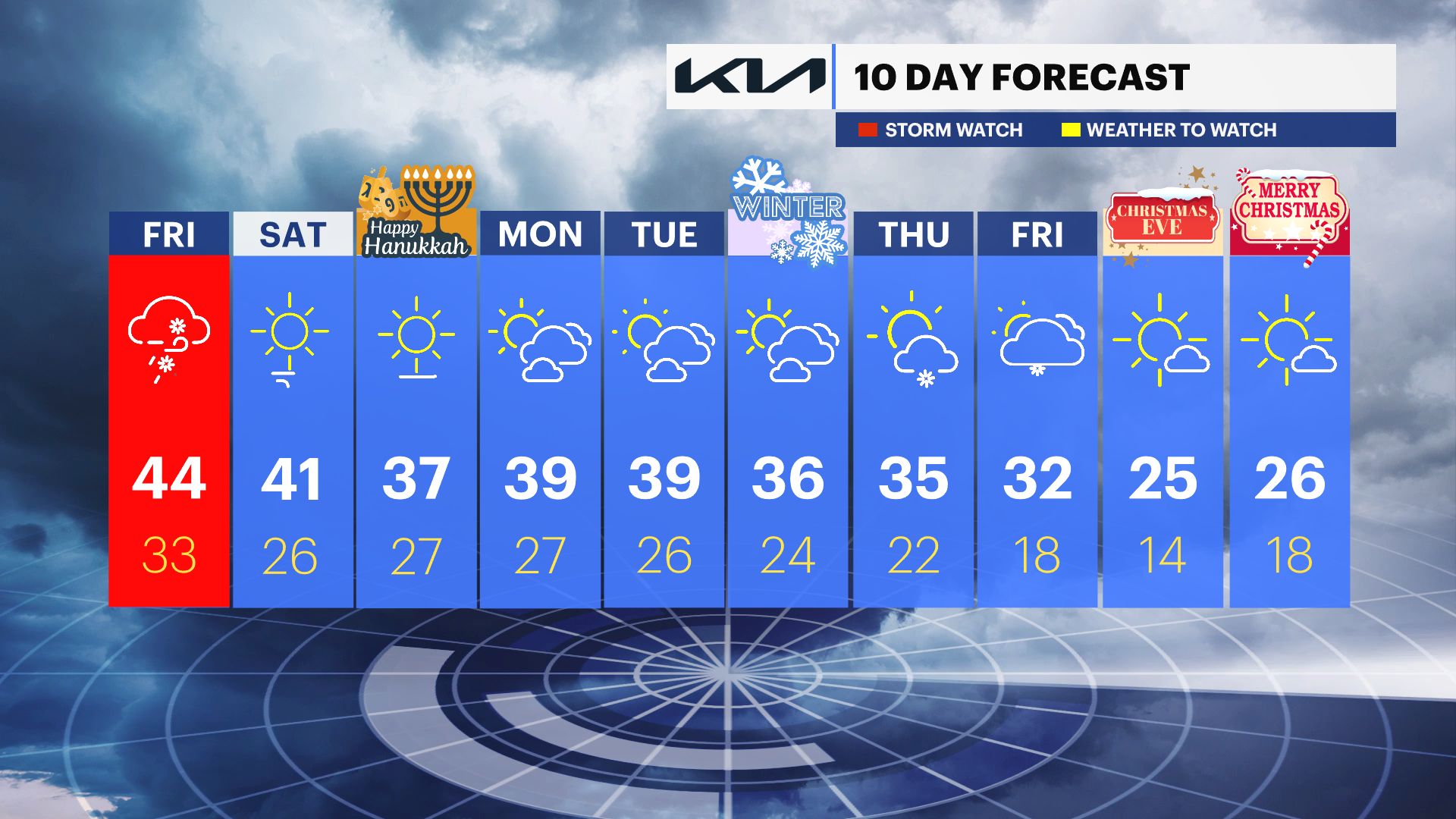
SATURDAY: Sunny with highs around 41 degrees. Lows around 26.
SUNDAY: Colder, but dry. Sun and clouds. Highs around 37. Lows around 27.
NEXT WEEK: Watching a winter storm threat for the end of the week in the Thursday-Friday timeframe. Its forecast position is bouncing around on the maps, it will likely bring something to the region. It's too soon to know specifics but stay up to date with the News 12 Storm Watch Team for continuing updates. Plan on a solid and confident forecast beginning Monday afternoon or Tuesday at the earliest. Any earlier forecasts that arrive Saturday or Sunday for snow totals and impacts on next Thursday-Friday should be taken with a grain of salt and subject to big changes.
More from News 12
2:09

Emergency sewer repair project in Greenburgh stinks – but it’s necessary, officials say
2:05

Chilly morning, pleasant afternoon Sunday in the Hudson Valley
1:58

Residents learn more about $12.9M facelift proposal for Nanuet Public Library
0:48

Rain doesn't damper celebration at 13th annual Italian Feast and Festival in Tappan
0:53

Nearly $2 million to fund intelligence center, body cameras for Orange County law enforcement
0:29
