Cloudy, breezy and cold overnight on Long Island ahead of a chilly weekend
Drier weather arrives in time for the weekend, but cold and breezy conditions will linger - dress warmly!
More Stories




OVERNIGHT: DRIER, BUT COLD
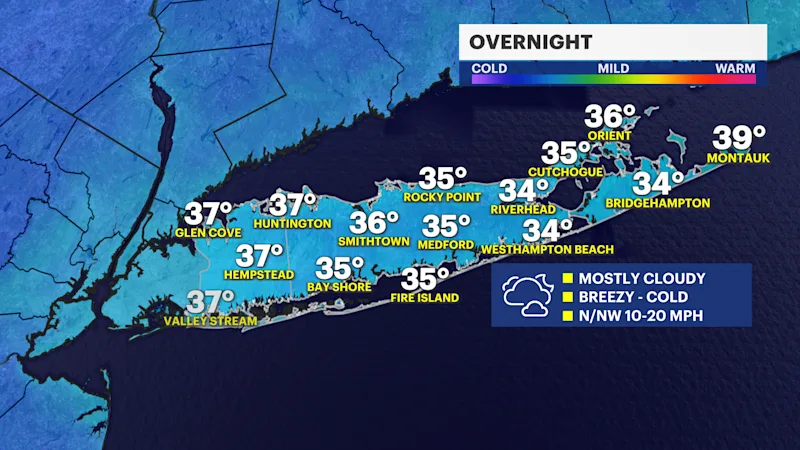
While roads can still be wet and slick, it is drier and mostly cloudy overnight. It continues to be breezy and cold. Wind gusts will stay mostly in the 10 to 20 mph range and it will feel like the upper 20s to lower 30s into Saturday morning - dress warmly! That said, it will be a nicer, but colder weekend and we will see breaks of sun return Saturday, with even more sunshine on Sunday.
STORM RAIN TOTALS RECAP
This recent nor'easter was one of those storms with a little bit of everything for Long Island. It was a true sign of the changing of seasons we are going through, from temperatures around 60 degrees with severe weather nearby to the colder weather moving in as it dries out overnight. It also provided around 1 to 2 inches of rain for much of Long Island. Wind gusts peaked at around 20 to 40 mph with a few isolated higher gusts, mostly across the East End. Here are some of the storm's total rainfall amounts below.
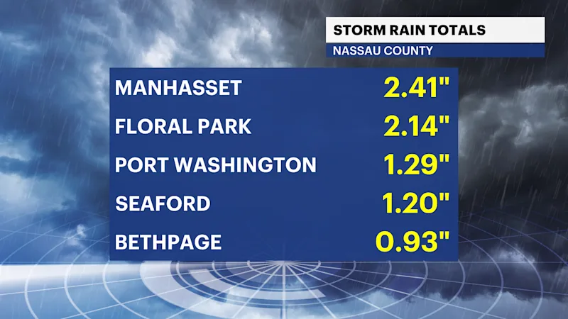
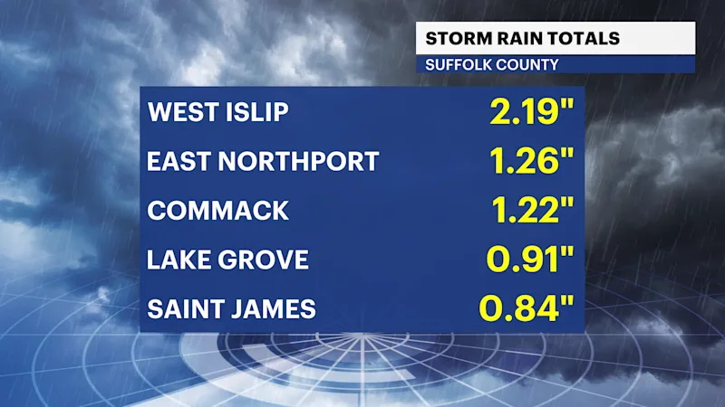
STAYING COLDER THIS WEEKEND
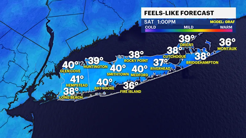
Dress warmly overnight and through the weekend. It will look nicer outside, but it will feel cold at times. The nights and mornings will be particularly cold. It can feel like the upper 20s to lower 30s Saturday morning.
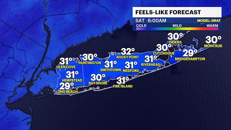
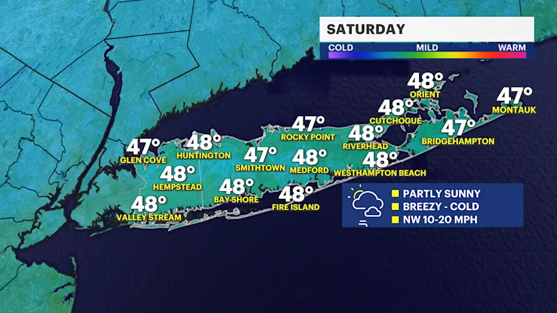
It will be chilly all weekend long, with high temperatures around the upper 40s to near 50 degrees, with another cold morning on Sunday. Frost will be possible during the nights and early mornings, too.
EXTENDED FORECAST
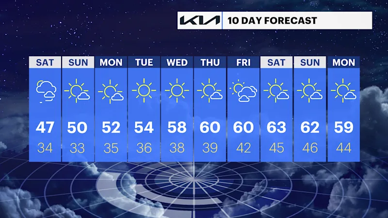
OVERNIGHT: DRIER, BREEZY AND COLD -- Mostly cloudy. Breezy and cold, too, with low temperatures in the mid-to-upper 30s. The north-northwest wind can still gust between 10 and 20 mph. This will make it feel like the upper 20s to lower 30s into early Saturday morning.
SATURDAY: NICE, BUT QUITE CHILLY -- Partly sunny, breezy and cold. It will feel like the upper 20s to lower 30s in the early morning. Highs will be in the mid-to-upper 40s, but it will feel like the upper 30s to low 40s in the afternoon. Wind: northwest 10 to 20 mph. Lows Saturday night will be in the middle 30s again and it can feel like the upper 20s to low 30s into Sunday morning.
SUNDAY: Mostly sunny to partly cloudy. Breezy and chilly with highs around 50 degrees. Lows near 33 degrees.
MONDAY: Mostly sunny. Highs near 52 degrees. Lows near 35 degrees.
TUESDAY: Sunny with highs around 54 degrees. Lows near 36 degrees.
WEDNESDAY: Sunny with highs around 58 degrees. Lows near 38 degrees.
THURSDAY: Mostly sunny with highs around 60 degrees. Lows near 39 degrees.
FRIDAY: Sun and clouds. Highs around 60 degrees. Lows near 42 degrees.