Mostly sunny through the weekend, possible showers for Monday
Showers will try to move in late Friday night, through the overnight hours, and wrap up before sunrise Saturday. The amounts will be very low.
More Stories


WHAT YOU NEED TO KNOW:
• Mostly dry conditions will be around through the weekend as the rain chances for Saturday morning have gone down.
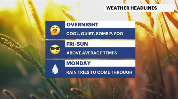
• There is a chance for patchy fog, in a few spots, for overnight into Friday morning. Afterwards, a pleasant day is expected with temperatures trending above average.
• Showers will try to move in late Friday night, through the overnight hours, and wrap up before sunrise Saturday. The amounts will be very low.
• Saturday has temperatures feeling more like late September or early October. This will be similar to Friday.
• Sunday looks nice and pleasant through the day, with a chance of some showers arriving overnight.
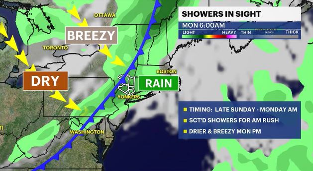
• A cold front approaches the region Sunday night into Monday morning. It will fire up scattered showers, that will last through the morning rush. Drier and breezy conditions will move in afterwards for the rest of the day.
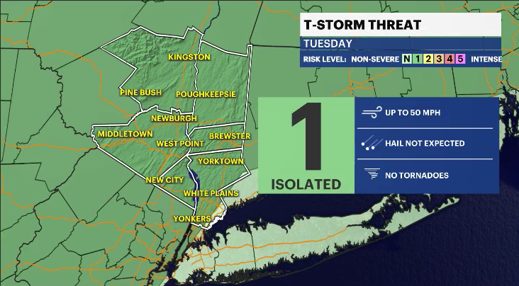
• Tuesday is partly cloudy and breezy at times, but dry and cool. Temperatures will trend below average for the rest of the workweek for both the highs and lows.
• TROPICS: There are three systems being monitored by the National Hurricane Center.
• Kirk is in the Central Atlantic Ocean and is forecasted to move northwest, in the open waters, and is a major hurricane. It doesn't pose a threat to any landmasses but may kick up some wave activity for Bermuda by the weekend.
• Tropical Depression thirteen recently strengthened into a Tropical Storm Leslie and could be a hurricane by Friday night. It is forecasted to travel through the open waters of the Central Atlantic Ocean and doesn't pose a threat to any landmasses.
• The third disturbance is in the Western Caribbean Sea and has a 0-30% chance of development in the next two to seven days as it heads northwestward into the Gulf of Mexico.
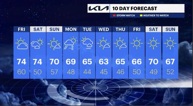
10-DAY FORECAST:
OVERNIGHT: Partly cloudy with patchy fog in spots. Lows: upper 40s to mid-50s.
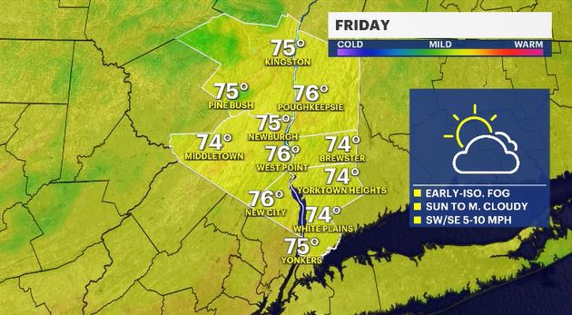
FRIDAY: Mostly sunny through much of the day with clouds later in the evening hours. Highs: low to mid- 70s. Lows: upper 50s to low 60s.
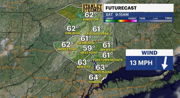
SATURDAY: Showers before dawn fade, mostly sunny skies to follow and a mild temperature trend. Highs: low to mid-70s. Lows: upper 40s to low 50s.
SUNDAY: Mostly sunny and pleasant. Highs: low 70s. Lows: mid-50s.
MONDAY: Mostly cloudy with scattered morning showers to partly cloudy and breezy afternoon. Highs: upper 60s. Lows: upper 40s.
TUESDAY: Partly cloudy and breezy. Highs: mid-60s. Lows: mid-40s.
WEDNESDAY: Mostly sunny. Highs: low 60s. Lows: mid-40s.
THURSDAY: Mostly sunny. Highs: mid 60s. Lows: mid-40s.
FRIDAY: Sunny. Highs: mid-60s. Lows: upper 40s to low 50s.
SATURDAY: Sunny. Highs: upper 60s to low 70s. Lows: upper 40s.
SUNDAY: Sunny. Highs: mid-60s. Lows: upper 40s to low 50s.