Snow for some, rain for many: Everything you need to know about Tuesday’s coastal storm
A dynamic coastal storm system is set to sweep across the tri-state on Tuesday, delivering the season’s first meaningful taste of winter for portions of the region while soaking others with heavy rain.
More Stories


Whether you’re grabbing the snow shovel or relying on rain boots, impacts of Tuesday's coastal storm will be felt across the region.
First plowable snow of the season for the Lower Hudson Valley and surrounding areas
Residents in the Lower Hudson Valley—particularly Ulster, Dutchess, and Orange Counties—should prepare for the possibility of significant snowfall. Current projections call for 3-6 inches, with locally higher amounts of 7 inches or more possible in higher elevations. The storm’s cold inland track favors these counties for accumulating, plowable snow.
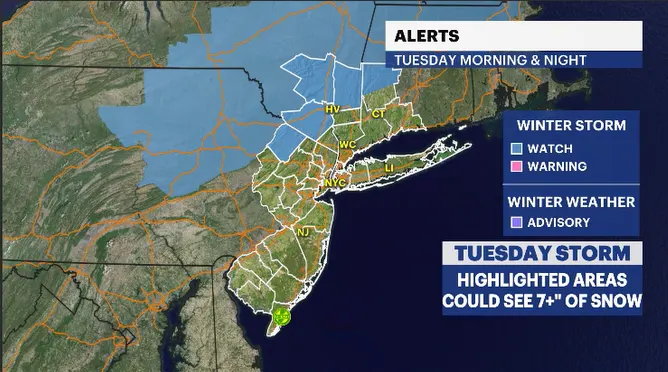
Neighboring regions will also feel winter’s punch. Northwestern Litchfield County in Connecticut and Sussex County in New Jersey are expected to fall within the same snow band, giving these areas similar accumulation totals.
Sharp precipitation cutoff creates challenging forecast
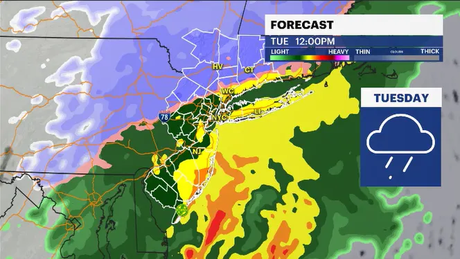
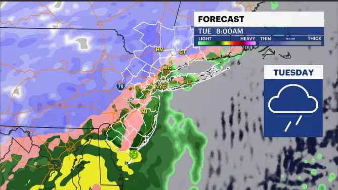
As is common with early-season systems, the boundary between rain, sleet and snow will be sharp and highly dependent on elevation and exact storm track. Areas just a short distance apart may experience dramatically different conditions.
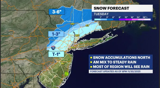
Westchester and Rockland counties in New York, along with northern New Jersey counties, may start Tuesday with light snow or a wintry mix, but temperatures will rise quickly enough to change most of this precipitation to steady, moderate rain by late morning. Some pockets of heavy rainfall are likely.
Rain for most of the tri-state
For New York City, Long Island, most of New Jersey and the shore regions, Tuesday is shaping up to be a cold, soaking rain event. Rainfall totals over one inch are expected, with locally higher amounts possible where heavier bands set up. While the flooding risk remains low, periods of ponding and minor roadway flooding cannot be ruled out.
Travel impacts likely
No matter the type of precipitation you see, Tuesday will be a messy day for travel:
Snow-prone regions can expect slippery roads, reduced visibility, and difficult travel, especially during the morning hours.
Rain-soaked areas may experience slow commutes, pooling water, and gusty winds in spots.
Higher elevations in the snow zones will see the most meaningful accumulation and should be prepared for plow operations and potentially hazardous road conditions.
Stay with News 12 for updates
As the storm evolves and the rain/snow line wobbles, small changes could make a big difference in who sees heavy snow versus heavy rain. Stay with News 12 as we continue to monitor, update, and track this impactful coastal storm, bringing you the latest information to help you plan your Tuesday safely.


