STORM WATCH: Hot and humid, watch for storms today in the Hudson Valley
We're tracking scattered thunderstorms this afternoon and another chance for the weekend. Here's the latest timing.
Share:
More Stories
1:16
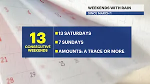
Streak of weekends with rain set to continue for lower Hudson Valley
3ds ago2:29

Sunny and clear Monday in the Hudson Valley before temps soar later this week
4ds ago2:29

Memorial Day weekend ends with beautiful evening in the Hudson Valley
10ds ago
News 12 weather blog
21ds ago2:29

Sunny and pleasant Monday in Hudson Valley; more rain chances this week
25ds ago0:55

Thunderbolt 12: Checking out the road conditions in Westchester
31ds ago1:16
Streak of weekends with rain set to continue for lower Hudson Valley
3ds ago2:29
Sunny and clear Monday in the Hudson Valley before temps soar later this week
4ds ago2:29
Memorial Day weekend ends with beautiful evening in the Hudson Valley
10ds agoNews 12 weather blog
21ds ago2:29
Sunny and pleasant Monday in Hudson Valley; more rain chances this week
25ds ago0:55
Thunderbolt 12: Checking out the road conditions in Westchester
31ds agoThis morning is the hottest and most humid so far this year, but with the summertime heat comes a chance for summer-like thunderstorms later today. Pop up thunderstorms are expected this afternoon and again midday tomorrow. It's not as hot this weekend, temperatures may actually drop a few degrees below average by Sunday and Monday.
TODAY: Watching for Afternoon Storms

It's a hot and humid morning with temperatures quickly rising into the low 80s before noon time. Skies are mostly cloudy with pop up storms developing after 1 p.m. becoming more likely after 3 p.m. Storms will dissipate this evening, after 8 p.m. with lingering showers overnight. High temperatures are in the mid 80s.
SATURDAY: Morning Rain Risk, then nicer

Pop up showers or storms are expected on Saturday morning. It's not a washout. The best chance for rain will come with a passing cold front on Saturday between 11 a.m. and 4 p.m. After the front passes, dry weather is expected. Highs are in the mid 70s. Humidity decreasing later in the day.
SUNDAY: Late Day Shower

It's less hot with a mix of sun and clouds for most of the day but watch out for a passing shower on Sunday evening. Highs near 70.
MONDAY: Pleasant
A morning shower is possible, then expect a mix of sun and clouds with highs in the low to mid 70s.
TUESDAY: More rain
We're tracking another batch of showers and storms on Tuesday. Highs will be near 70F.
REST OF THE WEEK: Heating Up
Temperatures will gradually soar into the mid or upper 80s by the end of next week. The hottest weather will arrive on Thursday and Friday with more seasonable weather returning next weekend.

More from News 12
2:29
Sunny and clear Monday in the Hudson Valley before temps soar later this week
2:29
Memorial Day weekend ends with beautiful evening in the Hudson Valley
News 12 weather blog
2:29
Sunny and pleasant Monday in Hudson Valley; more rain chances this week
2:29

STORM WATCH: Downpours possible overnight in the Hudson Valley
1:28
